Tom Butt
 
  E-Mail Forum – 2019  
  < RETURN  
  Invitation to Nov. 16 Grand Opening of Richmond-San Rafael Bridge Bay Trail
November 7, 2019
 

The big day has arrived! Below is an invitation for you, your family and friends to help celebrate the long-awaited opening of the Bay Trail across the top deck of the Richmond-San Rafael (RSR) Bridge on Saturday, November 16. This marks the first time in history for walking and bicycling between the East Bay and North Bay, leaving only the Bay Bridge west span and San Mateo Bridge lacking a Bay Trail crossing of the Bay. Moreover, for the first time since construction of I-580, it will be possible to safely walk and bicycle from Point Richmond to Stenmark (formerly Western) Drive, which is the trailhead for the RSR Bridge Bay Trail.

Credit for the five years of planning, design, funding and construction for this 10-foot-wide, two-way trail separated from motor vehicle traffic goes to the Bay Area Toll Authority and Metropolitan Transportation Commission with the Bay Trail Project, Bike East Bay, TRAC and Marin County Bicycle Coalition supporting and advising on decisions such as trail width, alignment and signage.

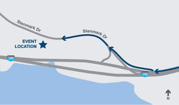
Whether coming on foot or by bicycle, car or public transit, be sure to CLICK HERE for a detailed access map and information on trail distances and points of access on foot, bicycle and public transit. (http://www.pointrichmond.com/baytrail/pointsanpablo.htm)

If coming by bicycle, CLICK HERE for detailed instructions on riding to the RSR Bridge Bay Trail from Richmond BART station (https://bikeeastbay.org/news/getting-bridge). This has the bonus of allowing you to check out the Richmond Greenway and sparkling new cycle tracks just installed by the City of Richmond to connect the Greenway with Point Richmond and the RSR Bridge. Consider accepting Bike East Bay’s invitation to join them in riding from Richmond BART to the opening day ribbon-cutting, especially if you coming from points afar such as Alameda, San Francisco or eastern Contra Costa counties (https://bikeeastbay.org/civicrm/event/info?reset=1&id=1554).

Please share the attached invitation with your family and friends via email, social media and perhaps even handing them a printed a copy. 


Background bridge illustration with text reading You're Invited to the Ribbon-Cutting! Richmond-San Rafael Bicycle & Pedestrian Path

Saturday, November 16, 2019 at 10:00 a.m.

961 Stenmark Drive, Richmond, California

Please join the Metropolitan Transportation Commission and Bay Area Toll Authority, Caltrans, Contra Costa Transportation Authority and the Transportation Authority of Marin in celebrating the opening of a new six-mile Bay Trail segment, allowing bicyclists and pedestrians to travel between Contra Costa and Marin counties for the first time. Please join us to celebrate!

SPEAKERS WILL INCLUDE REPRESENTATIVES FROM

Bay Trail Project
Caltrans District 4
CCTA
Chevron
City of Richmond
MTC/BATA
TAM


An illustrated map marking the event location with a star near Stenmark Drive.

Bike or Walk to the Celebration

Use the new path to join the festivities! Bicyclists and pedestrians can access the path from the intersection of Tewksbury Avenue and Castro Street in Point Richmond, or from the intersection of East Francisco Blvd. and Main Street in San Rafael. Follow the path to Stenmark Drive near the Richmond-San Rafael Bridge toll plaza, then follow Stenmark Drive a short distance up the hill to the event site. Bike racks will be provided for cyclist parking.

Driving Directions to Event Location

From the East Bay: Take the Stenmark Drive exit off westbound I-580 (this is the last exit before the Richmond-San Rafael Bridge). After exiting, stay in the center lane to proceed onto Stenmark Drive. Continue approximately 300 yards on Stenmark Drive to an entrance gate on the left that will be open.
From Marin County: From Marin, you will need to turn around in Point Richmond and re-enter the freeway to access the site from I-580 west. From the Richmond-San Rafael Bridge, take the first exit (exit 7) toward Richmond Pkwy/Point Richmond, turn slight left onto Castro Street and get on I-580 west. Take exit 7A toward Stenmark Drive/Pt. Molate. Follow Stenmark Drive to the site.
Drive a short distance up to the event site and follow the parking signs. Directional signs will be placed along the route. Please note there is absolutely NO parking allowed on Stenmark Drive. Plenty of motorized vehicle parking will be available at the event site.
A navy blue ine for the footer.
The new bicycle/pedestrian path is separated from auto traffic on the Richmond-San Rafael Bridge by an innovative moveable barrier on the bridge’s upper deck, extending the Bay Trail to link Contra Costa and Marin counties. Please help us celebrate this historic milestone for the Richmond-San Rafael Bridge and bicyclists and pedestrians around the Bay Area!
Logos for six partner agencies: MTC, BATA, TAM, CCTA, Caltrans and Bay Trail.A navy blue ine for the footer. 


This email was sent to

tracbaytrail@earthlink.net using GovDelivery Communications Cloud on behalf of: Metropolitan Transportation Commission · 
375 Beale Street, Suite 800 · San Francisco, California 94105 · ph: 415-778-6700 · www.mtc.ca.gov


  < RETURN