Since posting Dec. 8 Open House Briefing on Construction of Point Molate & Richmond/San Rafael Bridge Bay Trail Sections, December 2, 2016, I have received several questions about why an additional lane is planned to be opened on the bridge eastbound but not westbound, since there is a significant traffic backup in the mornings on the east end of the bridge.
You can probably get more information if you go to the December 8 meeting, but here is some background:
There are actually two different but related projects funded by the Bay Area Toll Authority (BATA). The one to begin construction soon is the Point Molate Bay Trail section between Castro Street (south of I-580) and Stenmark Drive (north of I-580), which is an integral and necessary part of providing a third eastbound motor vehicle running lane across the bridge.
The second, which will not go out to bid until next Spring, is the Bay Trail to be installed on the top deck of the Richmond – San Rafael Bridge.
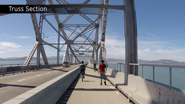
Both projects on the bridge, i.e. the third eastbound motor vehicle running lane and Bay Trail, are pilot projects to be evaluated after passage of four years in service. In contrast, the Point Molate Bay Trail section between Castro Street and Stenmark Drive will be permanent. The Bay Trail projects will provide 10-foot wide bi-directional multi-use trails, barrier-separated from the roadway and designed for use by both pedestrians and bicyclists. Their common purpose is to close a gap in the planned San Francisco Bay Trail route.
Quoting from the BATA executive director’s November 2, 2016, letter to BATA Oversight Committee:
The current lack of bicycle and pedestrian facilities across the RSR Bridge represents a major gap in the planned 500-mile Bay Trail, with sections of the Bay Trail adjoining the bridge on both sides. This contract will complete the connection from the Tewksberry/Standard Avenue Intersection in Point Richmond to Stenmark Drive near Point Molate. Two future contracts will be required to construct the path across the RSR Bridge and to complete the new path on the Marin County side of the bridge. Completion of this BATA project will result in the RSR bridge joining the Golden Gate, Carquinez Straits, Benicia and Dumbarton bridges, as well as the east span of the Bay Bridge, in providing Bay Trail pedestrian and bicyclist access.
Senate Bill 100, authored by then-state Senator Bill Lockyer and passed into law in 1987, directed the Association of Bay Area Governments (ABAG) to develop a plan for this regional trail system. The Bay Trail Plan, adopted by ABAG in July 1989, including a proposed alignment, and also was adopted by all of the cities and counties in the nine-county Bay Area. Policies governing completion of the Bay Trail and its alignment are included in Regional Bicycle Plan of the Metropolitan Transportation Commission, the Plan Bay Area Transportation Network, and the Contra Costa Countywide Bicycle and Pedestrian Plan, as well as the City of Richmond's General Plan 2030 and Bicycle Master Plan. The Bay Trail also is defined as a Priority Conservation Area in Plan Bay Area. The City of Richmond General Plan also states
:
- Action CR1.E Trails and Greenway Program: "Expand multi-use trails and greenways in the City. Provide connector trails and linkages to improve access from neighborhoods in Central Richmond to the regional open space in the hills and along the shoreline."
- Action CR2.A Community Access and Mobility : "Provide bicycle and pedestrian-friendly routes including completion of major trails and pathways like the San Francisco Bay Trail and Richmond Greenway."
CalTrans also has a mandate to provide “complete streets” even on highway projects. Deputy Directive 64-R2 (PDF) , first signed in October 2008, and renewed in October of 2014, directs Caltrans to implement complete streets.
Some motorists frustrated by the westbound I-580 morning traffic backup on approaches to the bridge are concerned about employing the right shoulder on the top deck for a barrier-separated walking and cycling trail. However, this morning backup normally is on the approaches to the bridge, rather than on the bridge itself, resulting from the confusion of motorists maneuvering for FasTrak vs. cash lanes in the midst of traffic merging from both the Garrard Blvd. and Castro St. on ramps just before the toll plaza. The pressing need is to eliminate cash toll collection as on the Golden Gate Bridge while finding a way to reconfigure the Garrard Blvd. and Castro St. on ramps.
Even if there were an additional third running lane added westbound, traffic would still snarl up on the west end of the bridge at a bottleneck where there are only two lanes on I-580 before it merges with State Route 101. Even the connection to Sir Francis Drake and 101 south has a single lane.
If you want to urge BATA to make the Richmond – San Rafael Bridge FasTrak only, like the Golden Gate Bridge, contact current MTC/BATA chair Dave Cortese at dave.cortese@bos.sccgov.org and incoming Chairman Jake McKenzie at blumacjazz@aol.com. Also contact CalTrans Regional Dircetor Bijan Sartipi at bijan.sartipi@dot.ca.gov. |