| |
Bay Bikers: The Bay Area's bicycle blog
Richmond-San Rafael Bridge bike path plans moving forward
By Brian Coyne on January 31, 2015 6:49 PM
After not just years but decades of advocacy, advances, and frustrating near misses, bicycle and pedestrian access to the Richmond Bridge at last appears set to move forward. On February 11th, the Bay Area Toll Authority, the agency that manages the region’s bridges, will meet to consider, and likely approve, a plan to add a third eastbound car lane to the bridge’s lower level and a bike and pedestrian path to the upper level. After that, the only remaining layer of approval still needed will be from Caltrans, which nixed earlier proposals for bike paths but appears likely to give this project its blessing. Crucially, full funding for the $74 million project, a figure that includes the roughly equal costs for the bike path and the added car lane, has already been secured. Assuming these final approvals go as planned, the bike path could be open by early 2018.
Courtesy MTC
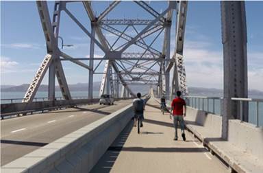
Image 1 of 12 |Richmond-San Rafael Bridge
Photo illustration of planned new bike lane and movable barrier across the 5.5-mile Richmond San Rafael Bridge.
The Richmond Bridge bike path is one of those rare infrastructure projects that will entirely reorder bicyclists’ mental maps of the Bay Area. Riding from Richmond to San Rafael today would be an 86-mile, five county odyssey around the north end of the Bay, a long detour made longer by the fact that CA 37, the direct route along the north shore, is unsafe and unpleasant for riding. Come 2018, the East Bay and Marin will instead be only 5.5 miles apart for bicyclists, opening up exciting new opportunities for both commuting and recreation. I’ve already got my inaugural ride on the new path planned: a 45-mile route that starts from San Francisco, goes across the Golden Gate Bridge to Marin, across the Richmond Bridge into the East Bay, and on to Treasure Island via the east span of the Bay Bridge, which by this summer will allow bicyclists to reach the island. While it will most likely be several more years before the west span of the Bay Bridge opens to bikes, the planned ferry between mainland San Francisco and Treasure Island may be up and running by 2018, allowing bicyclists to complete the loop back to downtown San Francisco on a ten-minute ferry ride. Especially once the west span of the Bay Bridge finally opens to bikes, you can expect a “Three Bridge Bike Loop” to feature in every guidebook and any bike-loving visitor’s tour of the area. On the East Bay side, the bike path will also allow safe access to the isolated and beautiful San Pablo Peninsula, the section of Richmond that juts out deep into the Bay from north of Point Richmond and holds recently reopened Point Molate Beach Park and gorgeous views out over the water in all directions. Both the bridge path and the route through the San Pablo Peninsula will become parts of the San Francisco Bay Trail, the long-term plan to establish access for hikers and bicyclists to 500 miles of Bay Area shores.
Bike commuters are also expected to use the new pathway. Renee Rivera, the advocacy director of Bike East Bay and the organization’s point person on the project, said in a recent conversation that a number of major employers in Richmond, including Chevron and SunPower, have been strong supporters of the project because many of their employees live in San Rafael and elsewhere in Marin and are eager to commute by bike. For people commuting between Marin and elsewhere in the East Bay, the 11-mile ride between downtown San Rafael and Richmond BART will put combined bike and transit commutes within easy reach.
Rivera emphasized the remarkable consensus in support of the bike path among all the public agencies and constituencies involved. The car congestion, and resultant push for more car capacity, has been most pronounced in the eastbound direction, and Rivera said that it was recognized from the start that a balanced project would be one that added both car capacity and access for people walking and biking. While a few commentators have fretted about the possibility that the bike access project would delay the opening of the added car lane, the car lane project is actually far more complicated and challenging due to the need to reconstruct retaining walls on the Richmond side. Rivera said the consensus among policymakers is that if anything the car lane project will end up delaying the bike path and not the other way around.
Assuming that it does give final approval to the project, Caltrans deserves significant praise for being a partner rather than an obstacle. Caltrans has recently declared that it is turning over a new leaf and would start taking the “Transportation” part of its name and mission to mean more than just “cars.” This change came after Governor Jerry Brown commissioned an independent review of Caltrans and the report, issued in early 2014, ripped the agency as regressive and hidebound, in large part for its failure to plan adequately for biking, walking, and transit. Rivera says that in her experience Caltrans’s attitude has genuinely changed since then. By formally approving the Richmond Bridge bike path, Caltrans can show definitively that its new way of doing business is more than just talk, and hopefully the agency will also bring this supportive attitude to other discussions about retrofitting Bay Area infrastructure for a multi-modal era. As anyone who follows Bay Area bike infrastructure projects knows, no major plans, and especially no estimated completion dates, are certain until you’ve got the asphalt under your tires, but on the Richmond Bridge, the signs are, at last, pointing in the right direction.
|
|