There will be a memorial service for Barbara Vincent at 12 Noon, Friday, November 2, Richmond Yacht Club, 351 Brickyard Cove Road.
Barbara was one of a small but determined and persuasive group of women in post-WWII Richmond who battled incessantly to make Richmond a better place. Their most tangible legacy is the vast amount of public access and thousands of acres of shoreline parks on Richmond’s 32 miles of shoreline. Barbara was also a champion of environmental justice and social equity, and inspired many of younger generations to take up and advance those causes in Richmond.
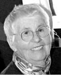
Barbara Moore Vincent 1916-2012 Resident of Richmond, Ca Her family and parents, Marie W. and Joseph H. Moore, were pioneers in Richmond's early development. Barbara was born in Richmond on March 6, 1916 and died on September 24, 2012, quietly, at her home, in Richmond.
Barbara was educated in local schools, University of California, Berkeley, B.S. Economics in 1937, and at age 50, became a student again by attending Hastings College of Law, San Francisco.
Her husband Jay predeceased her in 2005. An environmentalist and civic leader, she served on the Richmond Planning Commission, 1957 to 1969, and was the first woman chairperson in 1963.
A Board Member of Save the San Francisco Bay Association, serving from 1963 to 1991. She and her cohorts of "little ole ladies in tennis shoes" were major forces in the development of Richmond shoreline for public use. The shoreline Bay Trail, and parks that include Point Isabel, Miller-Knox, Point Molate, East Brother's Lighthouse, Point Pinole and San Pablo Reservoir, carry the imprint of Barbara's research, writing and organization efforts. Barbara and her late husband, Jay, both shared and championed this vision of public access to the shoreline, which in 1960, had but a 64 foot boat ramp, now Boat Ramp Park. In recognition of both of their years of community service, the City, in 1997, honored their contributions with the naming of the Barbara and Jay Vincent Park on the Bay Trail at Marina Bay.
Survivors are son's J. Michael of Suisun Valley, Stephen of San Francisco, and David of Richmond; grandchildren Tracy Ylarregui, Cathleen Ellis, Lucas and Pearl Ann McGee-Vincent and Alek Gent-Vincent; and great grandchildren, Ryan, Matthew, Katelin, Brian, Magan, Luke and Mason. Son Christopher preceded her in death.
Memorial Gifts: Save the Bay Association, 350 Frank Ogawa Plaza, Suite 900, Oakland 94612; Richmond Public Library Foundation, P.O. Box 70413, Richmond 94807.
Following is a story about Barbra from the 1987 West County Times:
West County Times February 14, 1987
Vincent, 70, maintains her devotion to preserving Richmond's environment
By Joe Pereira
Staff writer
RICHMOND — Every morning Barbara Vincent drives to the Plunge in Point Richmond to take a swim. It's her contribution to the environment. By swimming she stays healthy and keeping everything healthy — body, plants, water and air —is what an environmentalist is all about, reasons Vincent.
So it should come as no surprise that Vincent's name is well known among environmental groups such as the Sierra Club, Save the San Francisco Bay Association and Friends of Wildcat Canyon. She works with all of them.
Vincent's thinking goes like this: The marshlands of North Richmond must be protected from contamination because it is the start of the food chain. The crab lays its larvae, the larvae get eaten by fish, the fish get eaten by birds and so on. "Everything works in a complete cycle from the organism in the marshes to the food that is served on the table for dinner," she said.
Another motive underscores Vincent's participation in environmental issues. As a native Richmonder she likes to keep her hometown clean, she added. That's why when she is told she is difficult to reach she answers, "Oh if it's not one meeting it's another." At 70 she is off and running.
Vincent is currently attending public hearings on several issues.
She said she wants to ensure that the North Richmond Bypass, a highway cutting diagonally across from Pinole to the San Rafael Bridge, will not be built at the expense of San Pablo and Wildcat creeks, which run from the hills into the San Pablo Bay. "There use to be salmon in those creeks at one time. That was a long time ago," Vincent said.
She is also carefully watching the proposed development on Clark Road in El Sobrante near Wildcat Canyon Regional Park. "We want to preserve the open feeling of the park because when you're in the canyon you don't want to see all these houses appearing in the scene."
Vincent said she loves nature. Her love affair with it finds her driving down remote dilapidated streets whose signs have fallen off metal poles a long time ago. "Do you know," she asked, "we have a boardwalk right here in Richmond. People may be amazed that we do. It's really hard to get to but it's there right on the beach."
Forty years ago Vincent was fighting to put footprints on the beaches of Richmond. Back then, she said, only 65 feet of Richmond's 33 miles of beachland was public property. Beachcombers would have been trespassing on private property almost anywhere by the water.
Through efforts of environmentalists, however, the public today has access to a majority of the waterfront. Several stretches, including Point Isabel, Point Molate, Marina Bay, Miller-Knox Park, Keller Beach and Point Pinole, have become favorite vistas for many local residents.
"There's nothing more beautiful than looking out at Mount Tamalpais from any of those points," Vincent said.
The panoramic view Richmond enjoys is someday going to turn some of the city's land into prime property, she predicted. "Our city leaders ought to capitalize on this inherent quality of Richmond and people will be beating a path to our door," she said.
Industry lining the shores, including the port of Richmond, doesn't have to be moved elsewhere for Richmond's to sparkle. "I don't think there's anything wrong with our manufacturing plants and service industry. They now have to conform to stringent standards set by governmental watchdog agencies," she said.
The Chevron Oil Refinery, for example, is a place Vincent sometimes escapes to at night. Specked with moon-like tungsten lamps, the plant is bathed in what Vincent calls "a fantasy land aura."
"Have you seen it at night? It's like a castle on a cloud in the sky."
Vincent doesn't mind being tagged an activist, a label that has been put on her by more conservative circles, she said. "I'm the first to admit I not your average fundamentalist Republican. But I sincerely feel that to change Richmond into a city we can be proud of takes eternal vigilance. I will probably not see the transformation in my lifetime. But I want to share the feeling of knowing that I played a small part in that change." the willow grove on the right when park ranger Berta Gardner conducted me and park staffer Tom Lindenmyer on this walk.
Follow the path uphill. When you reach a junction, turn left. (The right fork of the trail deadends at a vista point.) Follow the left path as it goes along a little bench of land, then begins to climb.
En route you will pass places where jute netting is restoring vegetation to areas of erosion left by old motorcycle trails. The views of the bay are so engrossing as they change and broaden out that you may not notice these repairs. Nature has a way of healing its wounds, especially with a little help from its friends.
The first crest you reach is False Gun Vista Point. During World War II, the shipyards of Richmond felt vulnerable to enemy attack, at a time when armament was needed elsewhere, so big, bare logs, painted olive drab to resemble cannon, were laid on circular mounds of earth to simulate gun batteries. After you have chuckled at this odd little remnant of a military deception, look down on Brickyard Cove below.
Little Brooks Island, from which the long breakwater extends, was a gun club for Trader Vic Bergeron and crooner Bing Crosby for many years.
In the heyday of ferryboats, John Muir often walked from his home in Martinez to catch the ferry to San Francisco at Ferry Point, below. Fascinating as this shoreline is, it is the San Francisco skyline and the profiles of the Tiburon peninsula and Mount Tamalpais that will make you gasp at the panorama.
When you have enjoyed this lofty resting point long enough, walk to the other "gun emplacement" at False Gun Vista Point, about 100 yards north. Then start downhill on what is known as Crest Trail. At the low point of the saddle there is a path that veers off downhill on your left toward the little white building, easily visible. Take it if your knees feel weak. Otherwise, continue to climb northerly.
You are now on your way to Nicholl Nob, named for John Nicholl, who once owned the land hereabouts.
To me, this little eminence will always be Lucretia Edwards Nob, for its last, rather than first, private owner. Lucretia and her husband, tugboat captain Tom Edwards, spent every red cent of their life savings to purchase the nob at a time when it was slated for development. Like a one-family Nature Conservancy, they held the land unchanged until the park system could purchase it.
When you reach the paved road, turn right, uphill, to reach Nicholl Nob Vista Point, which has a 360-degree view. Ford Motor, Standard Oil of California, Santa Fe and the Pullman Coach company were all industrial pioneers that built below, but it was Henry Kaiser and the World War II shipbuilding industry that gave the area its biggest industrial impetus.
One would-be entrepreneur who never quite got off the ground was a man named Robert Botts, who invented-a flying machine. His prototype took off from Nicholl Nob and did a nosedive into the glen below.
When you have looked over this vast area, retrace your steps and follow the paving back downhill around the curve of the nob, until you are about 300 yards short of the automotive barrier.
A sign indicates the footpath that goes downhill, the Marine View Trail, once part of an old dirt road. Take it through light chaparral, bearing consistently left until you have passed the big water tank, once scheduled to stand on top of the nob. Ignore the first two right forks downhill and continue on to the third, which zigzags in large, easy switchbacks to make for easier descent.
All too soon you will be back at the trailhead, wondering that this unspoiled, 237-acre chunk of precious land should have survived to become a place of relaxation and pleasure for the public on the Contra Costa shoreline.
Click here for an article by Barbara about cruising the delta in 1940.