As the Contra Costa Times story below notes, a route for the Bay Trail connection across I-580 to the Point Molate and the San Pablo Peninsula is close to adoption. What is remaining is the $15 million to build it and some cooperation and funding from Caltrans.
The City Council will be taking up the issue of what Caltrans calls the I-580 Schofield Avenue and Western Drive Bridge Deck Replacements. See:
Caltrans, whose Mission Statement is “Caltrans Improves Mobility Across California,” has been remarkably disinterested of late in mobility in Richmond, and should be encouraged to not only rethink the proposed 11-mile detour proposed for the I-580 Schofield Avenue and Western Drive Bridge Deck Replacements Project but also to both engage in and help fund the Bay Trail connection across I-580 to the Point Molate and the San Pablo Peninsula. See letter from TRAC to Bijan Sartipi below the Contra Costa Times story.
Richmond moving ahead with missing link of Bay Trail
By Hannah Dreier
Contra Costa Times
Posted: 12/02/2011 04:19:38 PM PST
Updated: 12/03/2011 06:56:52 AM PST
Click photo to enlarge
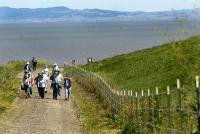
Bikers and hikers tour the new Landfill Loop Trail during the grand opening ceremony in...
In the coming years, bicyclists and hikers passing through Richmond on the Bay Trail will no longer have to brave a treacherous maze of surface streets and a highway shoulder to get from Castro Street to the Richmond-San Rafael Bridge.
Planners this week unveiled their proposal for the missing link in the Bay Trail. The new path will wind along the south side of I-580 for three-quarters of a mile, and when completed, will open a protected route from Point Richmond to the scenic Point Molate shoreline.
The trail now tapers off at Castro Street and picks up again just south of the bridge toll plaza. The only bicycle access to the Point Molate section of the trail runs along the shoulder of I-580. A bicyclist was struck and killed on the shoulder in 2006 and a fellow rider was seriously injured.
There is no pedestrian access.
"It's probably the most significant gap in Richmond as far as completing the trail," said Bay Trail planner Lee Huo. "It provides a critical connection to a place that has one of the most unique views in that area."
Richmond has 30 miles of completed trail, more than any among the cities in what is planned as a 500-mile network circling the Bay, with 11 miles more in the works.
"This is the capstone," said Bruce Beyaert, chairman of the Trails for Richmond Action Committee. "This will make it possible for the entire region to walk and safely bicycle to Point Molate: three miles of vacant shoreline with spectacular views of Mount Tamalpais and the Richmond-San Rafael Bridge."
The Point Molate gap has been especially hard to close because the route runs through private property and hilly terrain.
Bay Trail planners now will begin looking for the estimated $15 million needed to close the gap.
"This is example of how the Bay Trail can really serve a community by providing access to an area that's essentially inaccessible right now," Huo said.
Contact Hannah Dreier at 510-262-2787. Follow her at Twitter.com/hannahdreier.